
Hilfe im Wald
Contains ads

100K+
Downloads

Everyone
info


About this app
Help in the forest can save your life in the event of an accident:
The forest offers walkers, joggers, mountain bikers, horse riders, hikers, climbers, geocachers and children playing an important recreational area.
Foresters, forest managers, forest rangers, forest office managers, inspection officers, forest owners, hunters and drivers, felling entrepreneurs, forest supervisors, wood buyers and wood transporters are professional in the forest.
In the event of an accident, however, everyone needs quick help:
The Help in the Forest app currently has more than 59,000 rescue points in almost all federal states in Germany. Some rescue points are also available in Luxembourg. The database is constantly being expanded.
The fire brigade, the police and the paramedics are aware of the individual rescue points and the routes to get there, in some cases the Help in the forest app is also used there to find people to be rescued. If the ID of the next rescue point is given when the emergency call is made, help can be provided quickly.
This app makes an active contribution to a safe stay in the forest.
ATTENTION:
Please be sure to take the following steps BEFORE going into the forest:
1. Move and zoom the map section so that the area required offline is in the image section.
2. Download maps (ideally with an active WLAN connection).
Now we can start.
More functions:
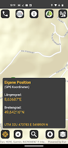
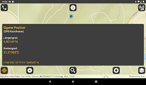
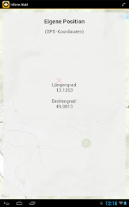
Turn on GPS to see your own location on the map and the direction you are walking.
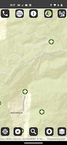
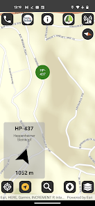
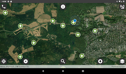
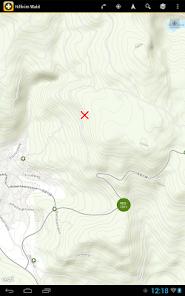
The rescue points are displayed as green circles with a white "+" - if you tap on a point, the name is displayed.
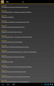
If you know the name of a rescue point, you can also find it using the search function.
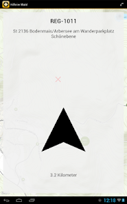
After selecting a rescue point, you can let the app guide you there: The distance and the direction are shown to you.
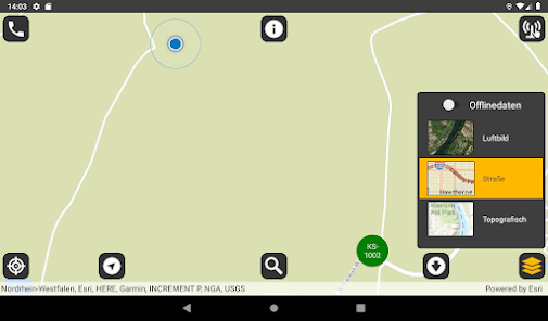
Use different map formats: aerial photo, road map, topographic map
If you need help, the app offers you a direct call option, 112 is the default.
Important NOTE:
Smartphone cases and magnetic objects next to the smartphone, e.g. in the same bag, can influence the sensors of the smartphone and consequently impair the functionality of the app.
The forest offers walkers, joggers, mountain bikers, horse riders, hikers, climbers, geocachers and children playing an important recreational area.
Foresters, forest managers, forest rangers, forest office managers, inspection officers, forest owners, hunters and drivers, felling entrepreneurs, forest supervisors, wood buyers and wood transporters are professional in the forest.
In the event of an accident, however, everyone needs quick help:
The Help in the Forest app currently has more than 59,000 rescue points in almost all federal states in Germany. Some rescue points are also available in Luxembourg. The database is constantly being expanded.
The fire brigade, the police and the paramedics are aware of the individual rescue points and the routes to get there, in some cases the Help in the forest app is also used there to find people to be rescued. If the ID of the next rescue point is given when the emergency call is made, help can be provided quickly.
This app makes an active contribution to a safe stay in the forest.
ATTENTION:
Please be sure to take the following steps BEFORE going into the forest:
1. Move and zoom the map section so that the area required offline is in the image section.
2. Download maps (ideally with an active WLAN connection).
Now we can start.
More functions:
Turn on GPS to see your own location on the map and the direction you are walking.
The rescue points are displayed as green circles with a white "+" - if you tap on a point, the name is displayed.
If you know the name of a rescue point, you can also find it using the search function.
After selecting a rescue point, you can let the app guide you there: The distance and the direction are shown to you.
Use different map formats: aerial photo, road map, topographic map
If you need help, the app offers you a direct call option, 112 is the default.
Important NOTE:
Smartphone cases and magnetic objects next to the smartphone, e.g. in the same bag, can influence the sensors of the smartphone and consequently impair the functionality of the app.
Updated on
Safety starts with understanding how developers collect and share your data. Data privacy and security practices may vary based on your use, region, and age. The developer provided this information and may update it over time.

No data shared with third parties
Learn more about how developers declare sharing

No data collected
Learn more about how developers declare collection
What's new
Wir haben die Liste unserer Datenlieferanten erweitert.